 Mantrio
Mantrio is the biggest city in Vixati.

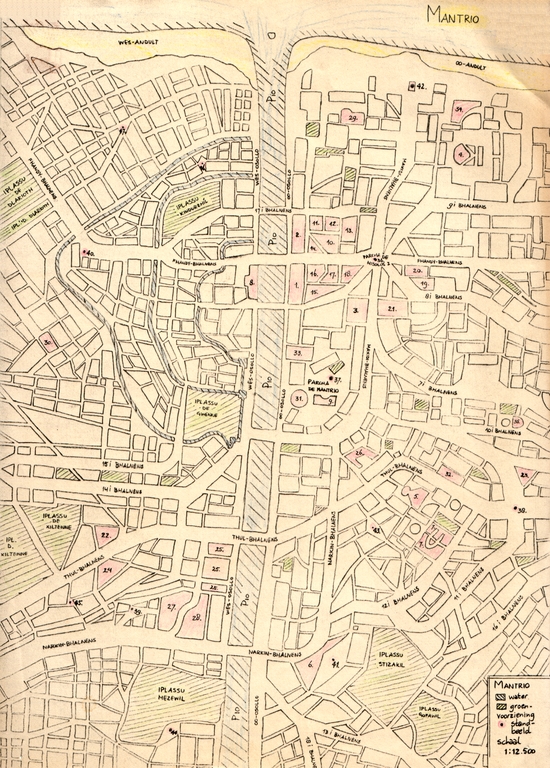
Map of Mantrio. Click to view a version of 924 KB.
The word 'bhalnens' means: boulevard, 'iplassu' means: park, 'andult' means: beach, 'osollo' means: bank, and 'parcha' means: square. All trains go underground. The following list with explanations of the numbers on the map is a part of the legenda.
1. Rohomi de na Rahoipate (people's representation)
2. Rohomi Afparrtis (senate)
3. central trainstation
4. city theatre 'Gorbenken'
5. theatre 'Suu'
6. former royal palace
7. museum of theatrical arts
8. Klopakial church
9. museum of musical history
10. ministry of foreign affairs
11. ministry of home affairs
12. ministry of justice
13. ministry of trade and social affairs
14. ministry of finance
15. ministry of education, science, media, arts and cultural affairs
16. ministry of traffic, public works and accomodation
17. ministry of agriculture, forestry and fishery
18. ministry of health, recreation and environment
19. museum of post-war Vixatian politics
20. the bank of Vixati
21. city hall
22. exchange hall
23. academy of arts 'Thorni'
24. Fracinistic church
25. state library
26. museum of literature
27. national museum of cultural history (years until 1102)
28. national museum of cultural history (years after 1102)
29. casino
30. television and radio studios
31. concert hall
32. conservatoire 'Sjalhi'
33. main court of justice
34. Fracinistic church
35. Lotidakistic church
36. statue of Hisolos I
37. statue of Cemote
38. statue of Thul
39. statue of Narkin
40. statue of Maxidi
41. statue by 'horte'
42. statue of Fhandy
43. statue of Carret
44. statue of Rende Inkel
45. statue of Ylov
46. statue of Obewil
47. statue of Xilten